Ahmed Shehta

Hi, I'm Ahmed Shehta

Project Manager | Senio

PMP‑certified project manager and software engineer with 10+ years delivering national‑scale GIS, AI, and digital‑transformation projects across Egypt and Saudi Arabia.

Scroll to explore

About Me

Experienced Project Manager with a Computer Science background and 10+ years leading national-scale projects in Egypt and Saudi Arabia across GIS, AI, remote sensing, and digital transformation. Proven ability to manage cross-functional teams of software engineers and GIS analysts while delivering complex solutions under both Agile and Waterfall methodologies. Holds PMP certification, a Master’s in GIS, an AI diploma, and multiple technical credentials. Seeking to drive innovation, improve operational efficiency, and deliver high-impact government and enterprise solutions.

Skills

Core / Proficient
Python92%
JavaScript90%
GIS & Remote Sensing89%
PostgreSQL (PostGIS)85%
Frameworks & Technologies
TensorFlow Scikit-learn FastAPI Flask Django React OpenLayers Leaflet Selenium
Databases / DevOps
PostgreSQL MySQL MS SQL Oracle Docker Kubernetes Linux CI/CD
GIS / Tools / Other
ArcGIS Pro QGIS ERDAS Apollo GeoMedia Pandas Charts.js .NET Core

Education & Roadmap

  1. 10/2025 — Present
    Master’s Degree in GIS (Geographic Information Systems)
    Zagazig University | Faculty of Computers and Information

    Master Degree program focused on advanced GIS concepts, spatial analysis, Structures, Web Dev, Databases.

  2. 09/2023 — 03/2024
    Master Diploma: Machine Learning & AI
    AMIT | Association of Management & Information Technology

    Diploma in Python , Data Science , Machine Learning , Deep Learning , Computer Vision , NLP , MLops

  3. 03/2020 — 06/2020
    Diploma: Open Source Development Using Python
    ITI | Information Technology Institute

    Learning All technology open source for Full stack development with Redhat administration 1 and 2

  4. 09/2013 — 09/2017
    Bachelor of Computer Science
    Zagazig University | Faculty of Computers and Information

    Graduate in Computer science field with GPA 2.4 from Faculty of Computer and Information Zagazig University

Work Experience

Senior Software Engineer
04/2025 - Present
GeoMakani — Jeddah, Saudi Arabia
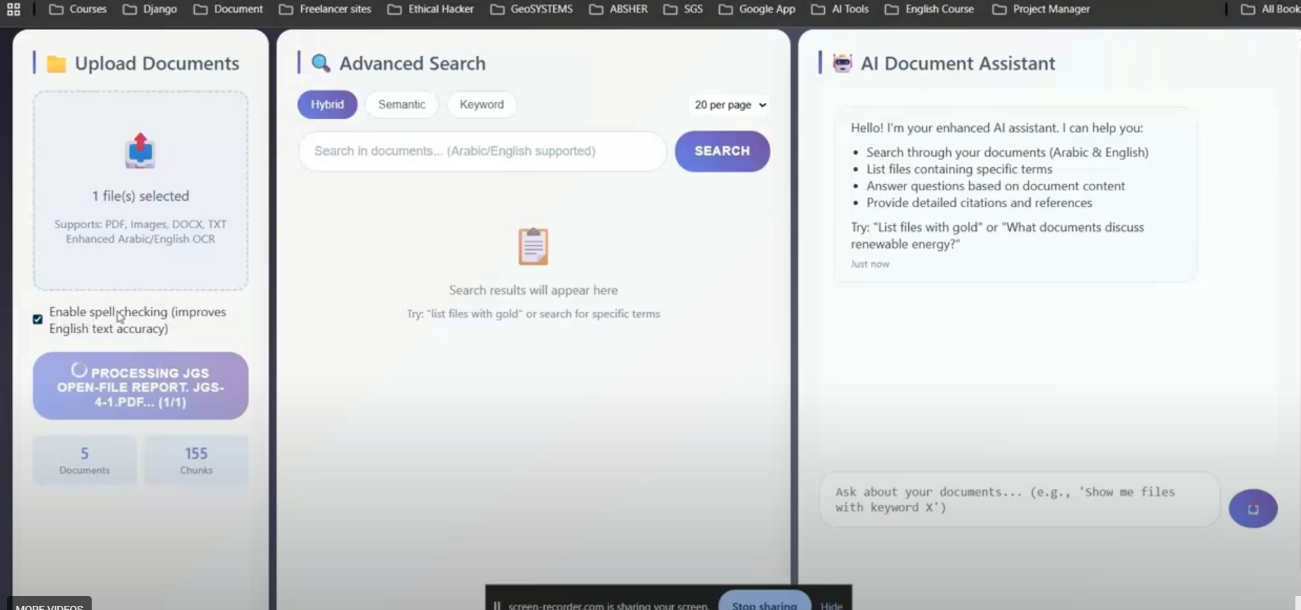
  • Built a smart archiving system using OCR, LLMs, and large-scale data compression.
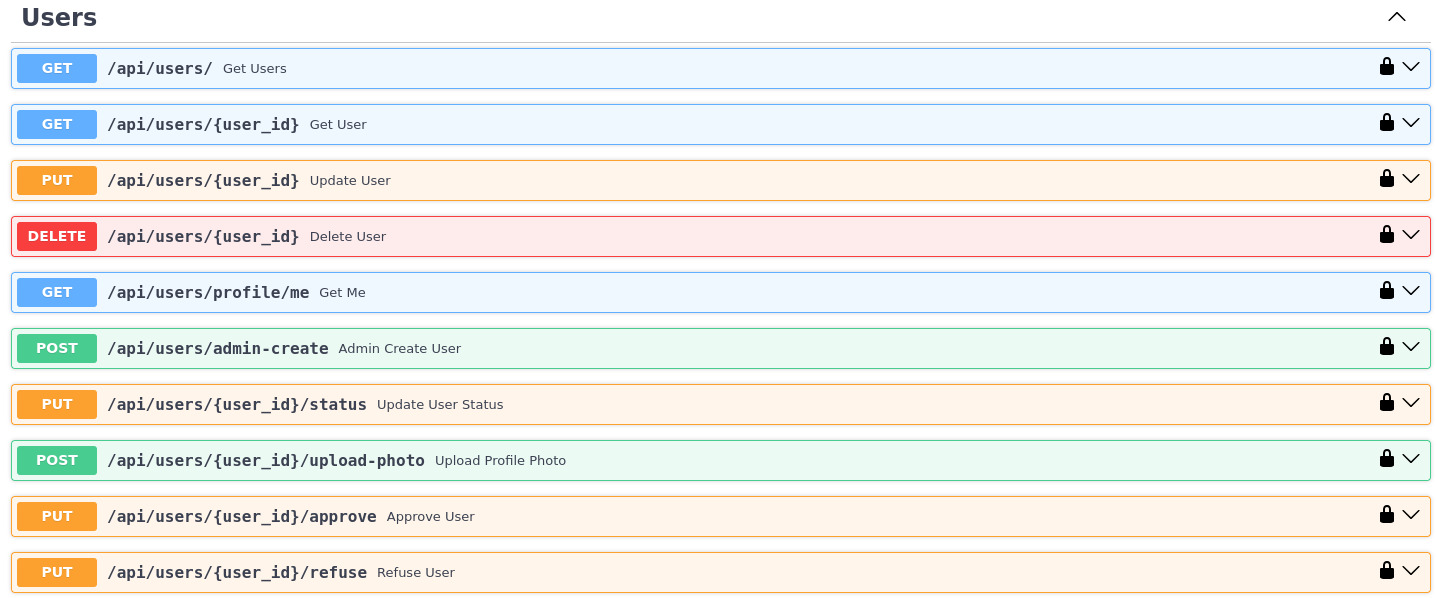
  • Designed and optimized modular APIs (Django, FastAPI, Flask).
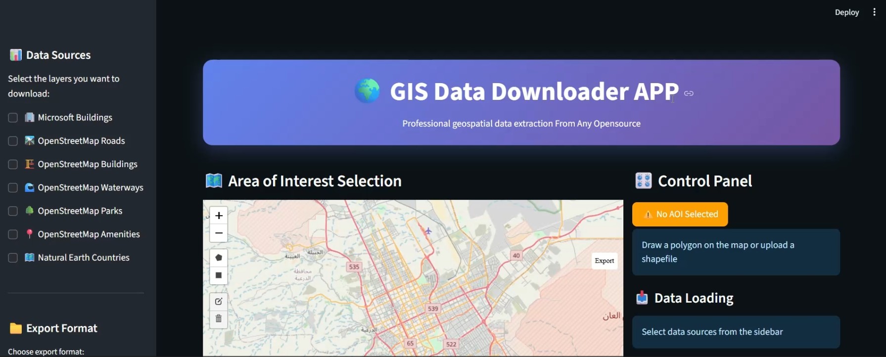
  • Built a professional geoportal and website with advanced GIS features.
  • Deployed solutions on on-prem servers using Docker, Kubernetes, CI/CD.
Project Manager
01/2025 - 03/2025
Alqotr Company — Riyadh, Saudi Arabia
  • Directed digital transformation and GIS-based national projects.
  • Ensured compliance with Saudi governmental standards and policies.
  • Led large teams for digitization and field data collection initiatives.
  • Aligned stakeholders with project scope, milestones, and deliverables.
Projects Manager
01/2024 - 12/2024
EDGE-Pro Company — New Cairo, Egypt
  • Oversaw four national-level projects across Egypt and Saudi Arabia (e-government, GIS systems).
  • Monitored progress, tracked KPIs, and provided comprehensive status reports.
  • Led Project Manager group in Egypt and coordinated remote teams in Saudi Arabia.
  • Supported change management for new technologies, workflows, and evolving requirements.
Project Manager & Scrum Master
01/2022 - 12/2023
EDGE-Pro Company — Cairo, Egypt
  • Delivered National Spatial Data Infrastructure (NSDI) Portal for Egypt with full government alignment.
  • Coordinated between government entities, consultants, and technical teams for smooth execution.
  • Prepared comprehensive technical reports, documentation, and handover packages.
  • Managed software team using Agile methodology; acted as Scrum Master for sprints and backlogs.
IT Manager & Full-Stack Developer
01/2022 - 12/2023
NSDI Project — EDGE-Pro Company, Cairo, Egypt
  • Headed IT operations for NSDI Project under Military Space Administration.
  • Developed full-stack applications using Django and modern web frameworks.
  • Managed inter-governmental system integrations with strict firewall policies and VPN tunnels.
Systems Branch Officer (Reservist)
11/2017 - 03/2020
Air Force General Hospital — Cairo, Egypt
  • Led the Computer Science Department and provided technical support.
  • Developed internal software solutions and web/desktop applications for hospital systems.
  • Contributed to system optimization and IT infrastructure improvements.

Top Projects

GIS Data Downloader v5.0

high-performance web application that enables users to select an area of interest (AOI) and download GIS data from various authoritative open data sources in professional formats. It's tailored for researchers, urban planners, geospatial analysts, and developers who need flexible access to clean, structured geospatial data.

StreamLit Python Microsoft Building Footprints open Street Map
AI Teacher-Student Platform

A Smart Educational Web Application built with Django that leverages AI-powered adaptive learning to enhance student engagement and personalize the learning experience. Currently in use by Menoufia University students, this platform delivers tailored educational content, intelligent assessments, and real-time assistance.

Django PostgreSQL LLM MCQ
Street Object Detection and GeoMapping App

This project is a smart object detection system that identifies buildings, doors, and windows from panoramic street images and maps them to accurate real-world coordinates using camera metadata.

Streamlit Roboflow GeoPandas Object Detection Deep Learning
PostgreSQL Auto Backup Tool

A powerful and user-friendly Windows application to automate PostgreSQL database backups using scheduled tasks.

Python PostgreSQL Tkinter Task scheduled Backup / Restore
NSDI GEO Portal
NSDI GEO Portal

An Enterprise National Spatial Data Infrastructure (NSDI) Web Portal designed for secure geospatial data management, sharing, and collaboration. Built with advanced authentication, role-based access control, and integrated GIS capabilities, the portal provides WMS, WMTS, and WFS services powered by OpenLayers and a custom backend.

Python Django Openlayers CMS GeoPortal
Daily Tasks Survey Application

A comprehensive web-based platform for task and progress management tailored for surveying teams. This application integrates GIS technology to provide real-time task tracking, geospatial data visualization, and secure progress monitoring.

Python Django PostgreSQL API integration GPS track
Smart Arcieve System (version2)

Professional document search, OCR, embedding and chat system built with FastAPI, FAISS and Sentence-Transformers.

pytesseract sentence-transformers FTS + semantic GPT/GPT4All Fast API
FastAPI Backend — Platform

Production-ready FastAPI service that powers the platform APIs. The repository ships with Docker support, GitHub Actions pipelines, and a clear path for both local development and containerized deployment.

FastAPI MS SQL Server Docker Performance Micro services Swagger

Certificates & Achievements

20 Verified Professional Certifications

PMP
EDU-Plus
2025 View
AMIT
AMIT AI/ML
2024 View
AMIT
ITI
2020 View
ESRI
Certificate For Attandance
2025 View
Oracle
Oracle OCI
2025 View
GIS
GIS Basics
2025 View
Remote
Remote Sensing
2025 View
Satellite
ArcGIS Satellite
2025 View
Mahara
Mahara Tech
2023 View
SCE
SCE Certificate
2025 View
CWW
CWW Development
2023 View
Management
Advanced Management
2024 View
Communication
Business Communication
2024 View
Strategic
Strategic Decision
2024 View
Appreciation
Appreciation 2021
2021 View
Appreciation
Appreciation 2023
2023 View
Thanks
Appreciation 2023
2023 View
Thanks 5
Appreciation 2025
2025 View
Thanks 4
Appreciation 2023
2023 View
Thanks 2
Appreciation 2020
2020 View

Get In Touch